About the project
The site is currently utilised as open rough grazing for livestock. It has good wind resource and lies within an 'area with potential for wind farm development' as defined in Dumfries and Galloway Council Local Plan 2 (2019).
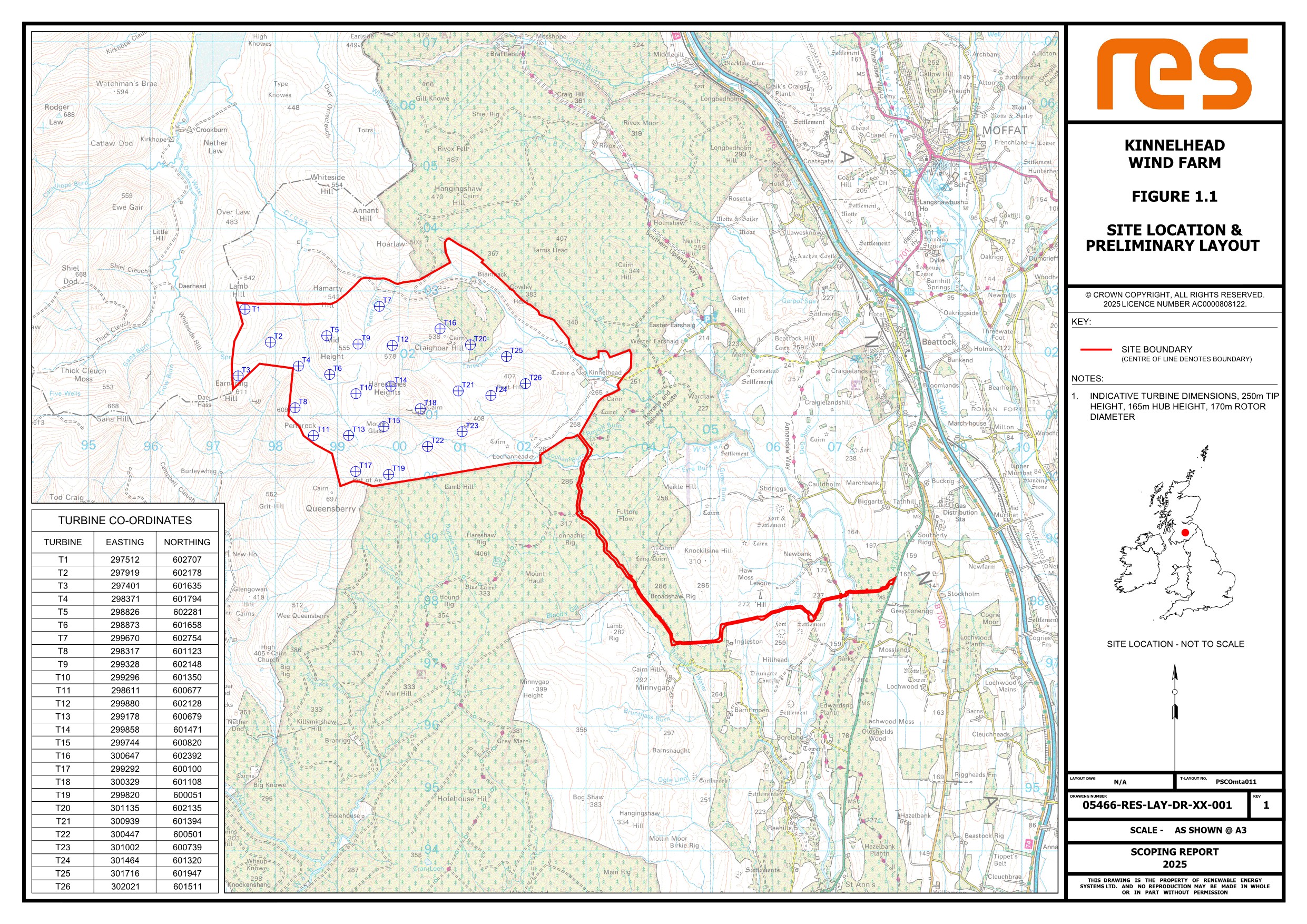
Based on our initial studies, the wind farm would comprise of up to 26 turbines up to a tip height of 250m, resulting in an overall site generating capacity of 171MW. This is enough to power around 225,000 homes1 with clean, low cost electricity, every year.
Click to enlarge
You can view or download a copy of the Scoping Report by clicking on the links below:
Figures
- Figure 1.1 Site Location Plan
- Figure 1.2 Layout Constraints Drawing
- Figure 4.1 Blade Tip ZTV with proposed LVIA viewpoints - 45km
- Figure 4.2 Blade Tip ZTV with proposed LVIA viewpoints - 20km
- Figure 4.3 Hub Height ZTV with proposed LVIA viewpoints - 20km
- Figure 4.4 Landscape designations & Blade Tip ZTV with proposed LVIA viewpoints - 20km
- Figure 4.5 Other Wind Farms within - 20km
- Figure 5.1 Designated Cultural Heritage Assets
- Figure 7.1 Ornithological Survey Area & Viewsheds
- Figure 8.1 Geology, Hydrology & Hydrogeology study area
- Figure 8.2 Bedrock Geology
- Figure 8.3 Superficial Geology
- Figure 8.4 Watercourses
- Figure 8.5 Peat Depth Interpolation
Appendices
- Appendix 5.1 Cultural Heritage Appraisal Table
- Appendix 8.1 Peat Instability Hazard Assessment Report
- Appendix 8.1 figures
- Figure A1 - Site boundary
- Figure A2 - Bedrock geology
- Figure A3 - Superficial geology
- Figure A4 - Carbon and peatland map
- Figure A5 - Topography
- Figure B1 - Peat depth at each probe location
- Figure B2 - Peat depth interpolation
- Figure C1 - Factor of safety v1
- Figure C2 - Factor of safety v2
- Figure C3 - Factor of safety v3
- Figure C4 - Factor of safety v4
- Figure C5 - Landslide susceptibility - slope angle
- Figure C6 - Landslide susceptibility - peat depth
- Figure C7 - Landslide susceptibility - substrate geology
- Figure C8 - Landslide susceptibility - peat geomorphology
- Figure C9 - Drainage
- Figure C10 - Landslide susceptibility - curvature
- Figure C11 - Forestry
- Figure C12 - Landslide susceptibility - land use
- Figure C13 - Overall landslide susceptibility score
- Appendix 9.1 Transport Access Scoping Report
The Scoping Report and supporting information is also available on the Scottish Government’s Energy Consents Unit website at www.energyconsents.scot using the reference number: ECU00006139.
As part of the planning process, RES will undertake an Environmental Impact Assessment (EIA). The purpose of the EIA is to investigate and alleviate any potential effects of a development on the natural, physical and human environment. An EIA includes the following assessments:
- Landscape & Visual
- Archaeology & Cultural Heritage
- Ornithology
- Ecology
- Hydrology, Hydrogeology & Geology
- Traffic & transport
- Noise
- Socioeconomics
The results of these surveys will be included in the Environmental Impact Assessment Report which will form part of any planning application that is submitted.